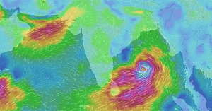
Port Blair, May 12: India has not witnessed any cyclonic storms during May since last two years. However, a tropical storm is likely to reappear over Indian seas in May 2016.
With the commencement of May, entire Indian East Coast along with Bangladesh and Myanmar becomes vulnerable to cyclonic storms.
According to Skymet Weather, a cyclonic circulation is expected to develop in extreme Southeast Bay of Bengal and adjoining Andaman Sea by May 13.
Thereafter, the system is likely to initially intensify into a low pressure area by May 14 or May 15 and then into a depression by May 16.
Further retaining strength for few days, the system may intensify into the first cyclone of the season by May 19. If this cyclone comes into the existence it will be named as ‘Roanu’.
Though the upcoming weather system poses a definite threat to Indian coastline but weather models are indicating that it may finally head towards Bangladesh or Myanmar coast.
According to Skymet Weather, weather conditions are favourable for the formation of cyclonic storm in Bay of Bengal.
One of the prominent features is the active Inter Tropical Convergence Zone (ITCZ) in Indian Ocean that will trigger the formation of cyclonic circulation in Bay of Bengal.
Other parameter required is the adequate sea surface temperatures that are quite favourable at present.
Moreover, Monsoon current also hovers just around the Indian seas during this time of the year.
Such systems during May hold great relevance for the country as they are primarily responsible for ushering in the Southwest Monsoon over Andaman and Nicobar Islands.
Accordingly, this brewing system will also lead to early onset of Monsoon 2016 over Bay Islands between May 18 and May 20. (Source: http://www.skymetweather.com)

Leave a Reply